
Antique Map Delineatio Obsidionis Urbis Stetini in Pomerania
browse these categories for related items...
Directory: Archives: Decorative Art: Pre 1700: Item # 1340236
Directory: Archives: Decorative Art: Pre 1700: Item # 1340236
Please refer to our stock # 773 when inquiring.
$295.00
295.00
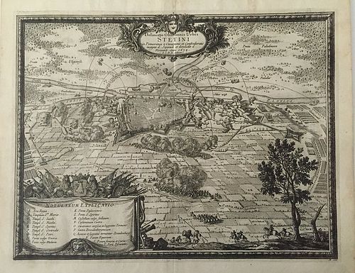
This rare engraving depicts the siege of Szczecin (Stettin), situated on the river Oder (north to the left), at that time part of Swedish Pomerania. A combined allied force of Poles, Austrains and Brandenburgians, under General Jean-Luis des Souches, invested the fortress on the 19th (29th) of September 1659. The besieged Swedish forces, under Major General Paul Wirtz, defended doggedly and eventually the besiegers gave up on the 6th (16th) November 1659. Plate 106 Background: In 1648, the Peace of Westphalia brought to an end the Thirty Years’ War and at the same time thwarted Sweden’s ambitions to control Baltic trade. Sweden was intent on gaining control of the whole of the Baltic trade (Dominium Maris Baltici) and the enormous customs duties deriving from it. All that was missing was control of the major ports on the southern coast of the Baltic or, alternatively, the Oresund, the gateway to the Baltic. A pre-emptive strike against Poland would isolate Prussia (east & west) forcing it to concede control of its ports, or at least pay Sweden a substantial amount of its income for ‘protection’. In July 1655 Karl X Gustav, King of Sweden, declared war and invaded the Commonwealth of Poland and Lithuania, giving rise to the 2nd Northern War, known in Poland as ‘The Deluge’. The Commonwealth was already weakened by fighting on two front; In the Ukraine it was attempting to suppress a war of independence whilst in the east Russian forces were overrunning Lithuania and Belarus. By superior tactical use of infantry and artillery, within the space of 4 months Karl X Gustav had overrun the whole of the area of present day Poland and forced the Polish King, Jan II Casmir, to flee the Country. All but a handful of the major stronghold gave up with just token resistance, the notable exceptions being Gdansk, Przemysl, Zamosc and Czestochowa. Two years later 'having conquered the Country but not the people' Karl X Gustav recieved information that the Danes had declared war on Sweden. Leaving some of his forces to hold various strongholds in Poland Karl X Gustav took 6000 of his most seasoned troops and marched to Denmark. This engravings comes from the book: De Rebus a Carolo Gustavo Sueciae Rege Gestis Commentariorum Libri Septem elegantissimis Tabulis Aeneis exornati (Sieben Bucher von denen Thaten Carl Gustavs Konigs in Schweden) Author: Pufendorf. S. Von, Published: Nuremberg, Christoph Riegel Date: 1696 The book is an account of the life and deeds of Charles Gustav during his reign as King of Sweden from 1654 to 1660. Engraver: ? Drawn by: Dahlbergh. Erik von, Condition: Very good ready for framing. Color: Uncoloured Size (h x w) 16.5" x 14" or 35 x 41.5 cm (approx. sheet size) Technique: Copper plate Scarce Samuel Pufendorf (1632-94): A German jurist and historian, he is especially noted as an early theorist of international law. In his later years, he served as royal historiographer at Stockholm and Berlin. Erik Dahlbergh (1625-1703): A Swedish field marshal, military engineer and cartographer, Count Dahlbergh was the author of a number of topographical works including the maps and plans in a famous account of the military exploits of the Swedish King, Charles X Gustav by Samuel Pufendorf. From July 1656 he served with the Swedish forces as military engineer and his engravings are that much more valuable in that they were made as an 'eyewitness'. The engravings are scarce and have great historic as well as artistic value showing as they do plans and elevations of towns & castles as well as the costumes of the period.
This rare engraving depicts the siege of Szczecin (Stettin), situated on the river Oder (north to the left), at that time part of Swedish Pomerania. A combined allied force of Poles, Austrains and Brandenburgians, under General Jean-Luis des Souches, invested the fortress on the 19th (29th) of September 1659. The besieged Swedish forces, under Major General Paul Wirtz, defended doggedly and eventually the besiegers gave up on the 6th (16th) November 1659. Plate 106 Background: In 1648, the Peace of Westphalia brought to an end the Thirty Years’ War and at the same time thwarted Sweden’s ambitions to control Baltic trade. Sweden was intent on gaining control of the whole of the Baltic trade (Dominium Maris Baltici) and the enormous customs duties deriving from it. All that was missing was control of the major ports on the southern coast of the Baltic or, alternatively, the Oresund, the gateway to the Baltic. A pre-emptive strike against Poland would isolate Prussia (east & west) forcing it to concede control of its ports, or at least pay Sweden a substantial amount of its income for ‘protection’. In July 1655 Karl X Gustav, King of Sweden, declared war and invaded the Commonwealth of Poland and Lithuania, giving rise to the 2nd Northern War, known in Poland as ‘The Deluge’. The Commonwealth was already weakened by fighting on two front; In the Ukraine it was attempting to suppress a war of independence whilst in the east Russian forces were overrunning Lithuania and Belarus. By superior tactical use of infantry and artillery, within the space of 4 months Karl X Gustav had overrun the whole of the area of present day Poland and forced the Polish King, Jan II Casmir, to flee the Country. All but a handful of the major stronghold gave up with just token resistance, the notable exceptions being Gdansk, Przemysl, Zamosc and Czestochowa. Two years later 'having conquered the Country but not the people' Karl X Gustav recieved information that the Danes had declared war on Sweden. Leaving some of his forces to hold various strongholds in Poland Karl X Gustav took 6000 of his most seasoned troops and marched to Denmark. This engravings comes from the book: De Rebus a Carolo Gustavo Sueciae Rege Gestis Commentariorum Libri Septem elegantissimis Tabulis Aeneis exornati (Sieben Bucher von denen Thaten Carl Gustavs Konigs in Schweden) Author: Pufendorf. S. Von, Published: Nuremberg, Christoph Riegel Date: 1696 The book is an account of the life and deeds of Charles Gustav during his reign as King of Sweden from 1654 to 1660. Engraver: ? Drawn by: Dahlbergh. Erik von, Condition: Very good ready for framing. Color: Uncoloured Size (h x w) 16.5" x 14" or 35 x 41.5 cm (approx. sheet size) Technique: Copper plate Scarce Samuel Pufendorf (1632-94): A German jurist and historian, he is especially noted as an early theorist of international law. In his later years, he served as royal historiographer at Stockholm and Berlin. Erik Dahlbergh (1625-1703): A Swedish field marshal, military engineer and cartographer, Count Dahlbergh was the author of a number of topographical works including the maps and plans in a famous account of the military exploits of the Swedish King, Charles X Gustav by Samuel Pufendorf. From July 1656 he served with the Swedish forces as military engineer and his engravings are that much more valuable in that they were made as an 'eyewitness'. The engravings are scarce and have great historic as well as artistic value showing as they do plans and elevations of towns & castles as well as the costumes of the period.